
08 Jul 2026
PlanningApplication for Rezoning to Residential Zoning 4 (Townhouse)
Qolorha Valley View
- Farm size
- null ha
- Plots
- 120 × 800m²
- Families
- Promotional price
- R 0
- Standard price
- R 0
Promotional pricing valid until - · full payment required to qualify.
Project Overview
A Planned Community on Titled Land
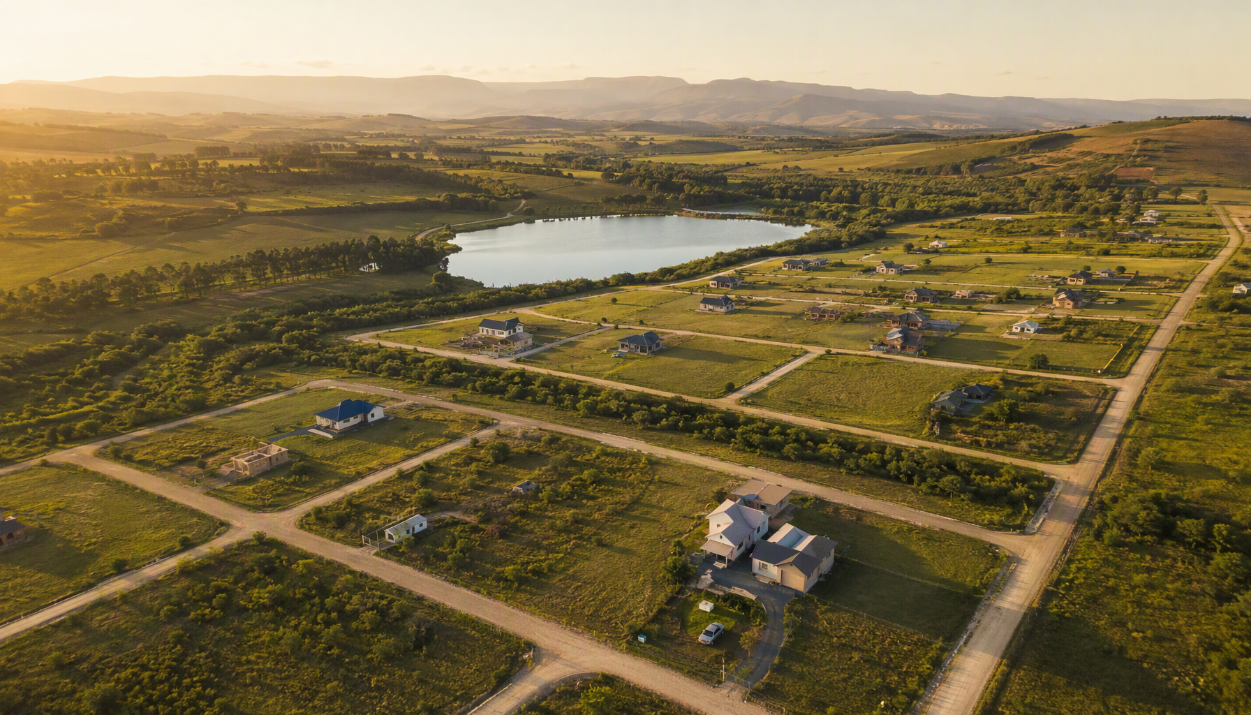
A future development by The Mheza Trust, planned for the Qolorha valley area. Currently in the land-acquisition and feasibility stage, Qolorha Valley View will follow the same legal, planned-community model proven at River Edge Rural Village and will likewise be administered by River Edge Primary Co-Op.
0
Available plots
0
Reserved plots
0
Sold plots
Interactive Farm Layout
Explore Every Plot
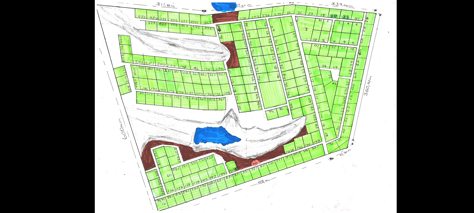
The full 31.9-hectare layout: 120 plots in five blocks, with erf numbers matching the official survey layout plan, primary and secondary roads, green belts and dams. Click any plot for details.
Surveyor layout: numbered plots, roads, dams and wetland buffers.
Official layout plan · boundaries 311.88m + 89.22m + 237.06m (north), 360.92m (east), 501.03m (south) · dams in blue, wetland buffers in brown.
100%
Development Plan
How the Land Is Subdivided
Subdivision
A land surveyor registered with SAGC has laid out the 31.9 hectares into 120 erven of 800m² each, in five blocks (A–E). Erf numbers in this system match the official survey layout plan, including subdivided erven such as 1A, 145A/145B, 165A, 186A and 203A. An application for Rezoning to Residential Zoning 4 (Townhouse) is being prepared for submission to BCMM.
Road network
Blocks are separated by 9–11m primary road reserves with internal 6m secondary roads between plot rows — every plot has direct road frontage and emergency access.
Green spaces
Green belts are set aside within the village, and both dam areas are protected with compliant setbacks and wetland buffers, giving the village communal open space and natural drainage.
Infrastructure
Modern Services, Rural Setting
Rainwater Harvesting System
Every plot is designed for rainwater harvesting: roof catchment from your home feeds a JoJo-style storage tank, providing household and garden water. This reduces dependence on municipal supply, lowers your running costs, and is endorsed in the development's water strategy. The farm's existing dam provides supplementary water for construction and communal use.
Septic Tank System
Each plot uses an individual septic tank with a French drain soak-away — a sanitation approach for which the BCMM Sanitation Division has issued a formal no-objection. Soil percolation testing has been completed to confirm suitability. The system is inspected at building-plan stage and requires no municipal sewerage reticulation, keeping plot costs affordable.
Eskom Electricity
An existing Eskom connection serves the farm. As rezoning is finalised, electrical reticulation will be extended to each block, with individual connections available to homeowners through standard Eskom application processes.
Road Network
Primary roads carry a 9–11m reserve and secondary roads a 6m minimum — wider than most urban subdivisions. Gravel-surfaced initially and designed for future upgrading, the network ensures emergency vehicle access, school transport, and all-weather usability.
Dam and Setback Compliance
The farm's dam is retained as a community feature with legally compliant setbacks. No plot encroaches on the dam buffer, and green belts surround it — protecting water quality and creating a natural recreational centerpiece for the village.
Community Values
The Rules That Keep River Edge Peaceful
Adopted democratically through the CPA and enforceable against every plot holder.
Residential only
The village is zoned for residential use — no industrial or commercial encroachment.
No animal farming
To maintain a peaceful suburban-rural environment, livestock farming is not permitted.
No slaughtering
Slaughtering on plots is prohibited, protecting hygiene and neighbourly comfort.
Peaceful, family-friendly
Noise, nuisance and illegal activities are governed by community rules adopted through the CPA.
Legal compliance
Building plans and land use follow municipal requirements — the Certificate of Land Use is issued per plot.
Democratic governance
Rules are made by members, for members, through the CPA's elected structures.
Rural heritage preserved
Green belts, the dam, and indigenous planting keep the rural character alive within a modern, compliant framework.
Project Timeline
The Journey So Far — and Ahead
Testimonials
What Our Members Say
“I bought Plot 49 for my three children. For the first time, our family will own land with a title — legally, safely. The Trust shows us every approval document they receive.”
Nokwanda Z.
Plot holder, Block B
“What convinced me was the status page. I could see the sanitation no-objection and exactly where the BCMM rezoning application stands myself. No other seller offered that kind of proof.”
Peter A.
Full-payment buyer
“The payment plan made it possible. I pay monthly and I can see my balance in the member portal. It feels like the Trust actually wants us to succeed.”
Thandiwe M.
Instalment plan member
Project Announcements
08 Jul 2026
BCMM Rezoning Guidance Received
08 Jun 2026
Sanitation No-Objection Received
Take the Next Step
Express Interest or Buy a Plot
Submit your details and a consultant will contact you within 24–48 hours.
Prefer to talk? Call us or visit the contact page to schedule a site viewing.